Glossary of Terms
Need a definition for some of the terms you are seeing as you navigate the Climate Data Portal to discover and download data? This glossary provides a guide to those terms. In most cases, a short version of the definition appears when you hover over the word.
| Term | Definition |
|---|---|
| Project |
Select the project which the data product is part of. Options currently include: NARCliM1.0 – Regional climate modelling based on CMIP3 global climate models, released in 2014 NARCliM1.5 – Regional climate modelling based on CMIP5 global climate models, released in 2020 |
| Product |
Select available data products. Options include: Post-processed – post-processed simulation outputs for each individual ensemble member Bias-corrected – bias-corrected simulation outputs for each individual ensemble member Multi-model statistics – a single dataset that combines the ensemble members, taking the average or mean values, a range, and other common statistics |
| Data Type |
Select a “package” for the data. Options include: Collections – a group of datasets with a targeted purpose to facilitate ease of downloading, such as all ensemble members for a specific variable. Datasets - individual datasets for a refined or specific selection option, such as an individual ensemble member. |
| Variables | Select one or many climate variables of interest. |
| Experiment / Scenario |
Select an experiment or emissions scenario. These include: Reanalysis – Simulations for historical periods (1990-2009 for NARCliM1.0 and 1951-2005 for NARCliM1.5). Reanalysis data is considered as reference data, i.e., closer to ‘truth,’ where observations are not available. Historical – GCM driven simulations of the historical period (1990-2009 for NARCliM1.0 and 1951-2005 for NARCliM1.5). Observations are not fed into the simulation as inputs. SRES A2 – CMIP3 scenario used in NARCliM1.0 simulations for the near future (2020-2039) and far future periods (2060-2079). SRES A2 assumes high greenhouse gas emissions in a regionally oriented world and strong economic development. RCP4.5 – Representative Concentration Pathway 4.5 - CMIP5 scenario used in NARCliM1.5 simulations for the future period (2006-2100). RCP4.5 assumes modest cuts in greenhouse gas emissions over the century and stabilised radiative forcing by 2100. RCP8.5 – Representative Concentration Pathway 8.5 - CMIP5 scenario used in NARCliM1.5 simulations for the future period (2006-2100). RCP8.5 assumes high greenhouse gas concentrations/worst-case scenario and represents the 90th percentile of a no-policy approach to climate change mitigation. For more information on SRES A2, click here: https://www.narccap.ucar.edu/about/emissions.html For more information on RCP4.5, click here: https://link.springer.com/article/10.1007%2Fs10584-011-0151-4 For more information on RCP8.5, click here: https://link.springer.com/article/10.1007/s10584-011-0149-y For more information on CMIP3 scenarios, click here: https://www.wcrp-climate.org/wgcm-cmip/wgcm-cmip3 For more information on CMIP5 scenarios, click here: https://www.wcrp-climate.org/wgcm-cmip/wgcm-cmip5 For more information on CMIP6 scenarios, click here: https://www.wcrp-climate.org/wgcm-cmip/wgcm-cmip6 For more information on reanalysis models, click here: https://climatedataguide.ucar.edu/climate-data/atmospheric-reanalysis-overview-comparison-tables |
| Frequency |
Select the frequency or time step for variables. This represents the time between each data point recorded, such as hourly, daily, monthly or seasonal). Higher frequency data (e.g., hourly, daily) are much larger size files and typically are for specialised uses. Lower frequency data (monthly, seasonal, annual) are much smaller size files and are usually more than sufficient for most analysis. |
| Spatial Domain |
Select the domain or spatial extent for where the simulations were performed. AUS-44i – also called CORDEX-Australasia, has a 50 km grid resolution and covers Australia, New Zealand and parts of Southeast Asia. NARCliMi –a 10 km grid resolution that covers all New South Wales, ACT and Victoria and large parts of South Australia and Queensland The lower-case “I” indicates that the data has been interpolated to a regular grid (WGS84). For more information on the CORDEX-Australasia domain, click here: https://cordex.org/ For more information on the NARCliM domain data, visit the "About" menu |
| Driving Global Climate model (GCM) |
Select a driving or parent model (reanalysis). Parent models are either global climate models (real observations not taken into consideration) or reanalysis models (an assimilation of historical observations) For more information on GCMs, click here: https://www.climatechangeinaustralia.gov.au/en/climate-campus/modelling-and-projections/climate-models/ For more information on reanalysis models, click here: https://climatedataguide.ucar.edu/climate-data/atmospheric-reanalysis-overview-comparison-tables |
| Regional Climate Model (RCM) |
Select the RCM used to downscale the parent model outputs. NARCliM projects have used WRF RCMs (Weather Research and Forecasting) Note that RCM numbering does not imply sequentially versioning but labels for different models used. For more information on WRF, click here: https://ral.ucar.edu/solutions/products/weather-research-and-forecasting-model-wrf |
| CMIP Ensemble Member | The initial conditions that were used by the parent driving model. |
| Long Wave Radiation Scheme | The schema used by this RCM to model long wave (infra-red and longer) radiation. Predominately affects outgoing energy. |
| Short Wave Radiation Scheme | The schema used by this RCM to model short wave (visible and shorter) radiation. Predominately affects incoming energy. |
| Surface Clay Scheme | The schema used by this RCM to model surface runoff. |
| Cloud Scheme | The schema used by this RCM to model the cloud formation. |
| Planetary Boundary Layer Scheme | The schema used by this RCM to model the outer boundary layer with space. |
| Land Surface Scheme | The schema used by this RCM to model the land (specific heat and emissivity). |
Terms and Conditions for NARCliM Project Data
Data Licensing
This NSW Climate Data Portal website contains information, data, documents, pages and images prepared by the NSW Government Department of Planning, Industry and Environment (the Department) and third parties. The Department supports and encourages the dissemination and exchange of publicly funded information and endorses the use of the Australian Governments Open Access and Licensing Framework (AusGOAL). Unless otherwise stated, all Department material available on the NSW Climate Data Portal is licensed under the Creative Commons Attribution 4.0 International (CC BY 4.0). The license terms can be viewed at Creative Commons.
Data Disclaimer
Data available on the NSW Climate Data Portal has been prepared in good faith, exercising all due care and attention, but no representation, express warranty or implied warranty, is made to the relevance, accuracy, completeness or fitness for purpose of this information in respect of any particular user circumstances. The climate data projections include an inherent degree of uncertainty. You are responsible for assessing the relevance of the data for your intended purposes.
The Department endeavours to make sure that information provided on this website is correct at the time of its publication. However, as necessary you should obtain independent advice before making any decision based on the information on this site. The information on this site is made available on the understanding that the State of NSW and the Department accept no responsibility or liability for any damage, cost, loss or expense incurred by you as a resultof:
- any error, omission or misrepresentation on this site
- any malfunction or failure to function of this site
- reliance upon this website’s material or any linked sites
- without limiting the above, any delay, failure or error in recording, displaying orupdating information, including but not limited to, data relating to credit holdings.
Where there are known limitations to the information provided online, we will include an explanation of these limitations wherever possible. If there is any material that you consider to be misleading or inaccurate, please let us know and it will be corrected as soon as possible.
Your Privacy
The Department will handle information you enter to access the NSW Climate Data Portal in accordance with the NSW Government’s and the Department’s privacy and security policies. The Department’s privacy practices are regulated by the Privacy and Personal Information Protection Act 1998 (NSW) and the Department’s privacy management plan. We will not disclose your personal information to anyone without your consent, unless legally required to do so. Your consent to disclose information may be sought by us or given by yourself for a specific purpose. For more information, please visit the Department’s privacy webpage.
Acknowledgement
Written work of any form, based in whole or in part on data provided by the NSW Climate Data Portal will acknowledge the data has been provided by the Government of New South Wales, Australia. This written work will include the following acknowledgement:
For NARCliM data released in 2014, ‘NARCliM1.0’
This work used data derived from the NSW and ACT Regional Climate Modelling (NARCliM)1.0 project and provided by the Government of New South Wales, Australia.
Citation: Evans JP, Ji F, Lee C, Smith P, Argueso D and Fita L 2014, Design of a regional climate modelling projection ensemble experiment, Geoscientific Model Development, 7, pp. 621-629). Data accessed via the NSW Climate Data Portal [on date].
For NARCliM data released in 2020, ‘NARCliM1.5’
This work used data derived from the NSW and ACT Regional Climate Modelling (NARCliM) Expansion (1.5) project and provided by the Government of New South Wales, Australia.
Citation: Nishant N, Evans JP, DiVirgilio G, Downes S, Cheung KW, Tam E, Miller J, Beyer K and Riley M, Introducing NARCliM1.5: evaluating the performance of regional climate projections for southeast Australia for 1950-2100 (Submitted for publication). Data accessed via the NSW Climate Data Portal [on date].
For the CORDEX domain component of the NARCliM data released in 2020
This work used data derived from the NSW and ACT Regional Climate Modelling (NARCliM) Expansion (1.5) project and provided by the Government of New South Wales, Australia.
Citation: Evans JP, Di Virgilio G, Hirsch AL, Hoffmann P, Remedio AR, Ji F, Rockel B and Coppola E 2020, The CORDEX-Australasia ensemble: evaluation and future projections, Climate Dynamics, DOI: 10.1007/s00382-020-05459-0.Data accessed via the NSW Climate Data Portal [on date].
FAQs
Understanding the new NARCliM1.5 (2020) climate projections
This document answers several frequently asked questions regarding the new NARCliM climate projections. For further information about using NARCliM data, please contact narclim@environment.nsw.gov.au.
What is NARCliM?
The New South Wales (NSW) and Australian Capital Territory (ACT) Regional Climate Modelling (‘NARCliM’) project began in 2011. The project was established because regional decision-makers and impact assessment researchers needed high-resolution climate change projections. Previously, climate change information had been at a scale that could not be used for localised, regional decisions. The current partners are the governments of NSW, ACT and South Australia and the Climate Change Research Centre (CCRC) at the University of NSW.
NARCliM covers 3 jurisdictions (NSW, ACT and Victoria), large sections of Queensland and South Australia and 5 capital cities (Sydney, Canberra, Melbourne, Brisbane and Adelaide). Climate projections are offered at a 10-kilometre grid cell resolution covering south eastern Australia (the NARCliM domain) and at a 50-kilometre grid cell resolution covering Australasia (the CORDEX-Australasia domain). A map of these areas is available on the AdaptNSW website
The NSW Government released the first set of NARCliM climate projections in 2014. These are referred to below as NARCliM1.0. The Government has released supplementary climate projections in 2020, referred to as NARCliM1.5.
What are the new features of the NARCliM1.5 climate projections?
The new projections offer some enhancements to the earlier ones. Notably, they use a later group of global climate models (GCMs) used in the Coupled Model Intercomparison Project-5 (CMIP5). They are offered for 2 Representative Concentration Pathways (RCPs) from CMIP5: RCP4.5 (some mitigation of greenhouse gas emissions) and RCP8.5 (very limited mitigation of greenhouse gas emissions). In response to user feedback, the new projections provide continuous data from 1951 to 2100. There are also additional variables and time steps that were not available in the 2014 projections. See the list of variables on the NSW Climate Data Portal data search tool.
The new NARCliM projections follow the CORDEX framework, which is consistent with international best practice. CORDEX is an initiative of the World Climate Research Programme, which guides the science and application of regional climate downscaling techniques.
What do I need to consider when using NARCliM1.5?
Before undertaking any work using NARCliM projections, users are required to review and accept the Terms & Conditions and must also adhere to the following advice.
Models chosen in NARCliM1.5 complement the NARCliM1.0 projections by modelling a plausible future that is generally warmer and drier than covered in NARCliM1.0 across south-eastern Australia. It is very important that users consider this when selecting NARCliM climate projections for their modelling. The differences are noticeable when looking at the far future simulation period. This is addressed in the NARCliM1.5 ‘flagship’ manuscript, which is currently in peer-review for publication. A link to this and other related peer-reviewed research publications is available on the NSW Climate Data Portal.It is also important to note that the NARClIM1.5 climate projections do not supersede or replace NARClIM1.0. When comparing CMIP5 GCMs used in NARCliM1.5 with CMIP3 GCMsused in NARCliM1.0(Figure 1) it is clear that, overall, the CMIP5 RCP8.5 GCMs project hotter and drier futures than the SRES A2 CMIP3 GCMs for south-eastern Australia. Dynamically downscaled regional projections, which are the NARCliM data, may reduce the spread of GCM future projections somewhat because they better account for the fine-scale physical features that can greatly affect regional climate, but that GCMs cannot resolve. NARCliM1.5 has been designed as a supplement to NARCliM1.0 in order to represent the range of future climate variability. Users are strongly advised that NARCliM1.5 is not a replacement for NARCliM1.0, rather, NARCliM1.5 complementsNARCliM1.0. Therefore, both sets of models shouldbe used to capture the range of future climate variability for south-eastern Australia.
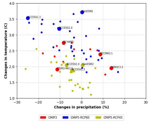 Figure 1. Changes in temperature and precipitation comparison between the CMIP3 (SRES A2) and CMP5 GCMs (RCP4.5 and RCP8.5) used in NARCliM1.0 and NARCliM1.5, respectively.
For any climate projections work, we recommend users explore the full range of NARCliM datasets before making a decision on model choice. Users are advised to be mindful of the importance of capturing the range of future climate variability in the selection of models. When selecting NARCliM models, users need to consider their limitations with regards to the type of analysis being conducted. Users are advised against selecting only NARCliM1.5 and disregarding NARCliM1.0. For more information on using climate models, please seethe webpage Guidance on using NARCliM on the AdaptNSW website.
How were the NARCliM climate projections developed?
Both sets of the NARCliM projections were initiated by the NSW Government’s Department of Planning, Industry and Environment (formerly the NSW Office of Environment & Heritage). The development of the NARCliM1.0 projections in 2014 was through a partnership between the NSW and ACT governments and the Climate Change Research Centre at the University of New South Wales (CCRC). Government partners in NSW included Hunter Water, NSW Office of Water, NSW Department of Primary Industries, NSW Department of Transport, Sydney Water and WaterNSW (formerly Sydney Catchment Authority).
The design and development of NARCliM1.5 projections was a joint venture between the NSW Government and the CCRC and included a consultative peer-review process with a technical working group and climate researchers from many of the same NSW Government partners.
For more detailed information about how NARCliM1.5 was developed, see the Technical Methods report available on the NSW Climate Data Portal.
Why did the NSW Government produce new regional climate projections?
Scientists are continually working to improve our understanding of the highly complex global climate system. As their research progresses, our knowledge of the climate systems improves and climate models are updated to incorporate this new information. The NARCliM1.5 projections use data from the CMIP5 GCMs, the same data used in the Intergovernmental Panel on Climate Change (IPCC) Fifth Assessment Report (AR5) reports and analyses. The GCMs used for CMIP5 GCMs offer incremental modelling advancements over the earlier GCMs used in CMIP3.
The NARCliM1.5 dataset enables technical users such as climate modellers to test methodological approaches for climate modelling, or to undertake stress testing and will be used by the NSW Government in preparation for development of the next generation of climate projections using CMIP6 GCMs.
How do the new NARCliM climate projections compare with the 2014 projections?
Both NARCliM1.5 and NARCliM1.0 climate projections have been produced using a very similar modelling approach. NARCliM1.5 GCMs were selected using the same 3-step process as for NARCliM1.0 GCMs:
- A review of literature to exclude the worst performing GCMs
- Testing for model independence
- Assessing the range of models’ future changes in rainfall and temperature
Both sets of NARCliM projections were developed using dynamical regional downscaling from the Weather Research and Forecasting (WRF) model, utilise the same Regional Climate Model (RCM) configurations and cover the same spatial extent and use the same grid resolution. The NARCliM1.0 projections simulate one historical and 2 future time periods (2030 and 2070) under one future emissions scenario (SRES A2). The NARCliM1.5 projections simulate a continuous period from 1951 to 2100 for 2 future emissions scenarios (RCP4.5 and RCP8.5).
The specifications of the 2 sets of projections are:
1Special Report on Emissions Scenarios (SRES) A2 represents the ‘business-as-usual’ scenario.
2RCP4.5 and RCP8.5 represent pathways with moderate emissions mitigation and very little mitigation, respectively.
Furthermore, preliminary analysis reveals that NARCliM1.5 simulates historic climatologies with similar results comparable to the 2014 projections for maximum and minimum temperature, with some improvements to overall ‘bias,’ (where simulations can deviate from the observed climate). For the future simulation periods (2020 to 2039 and 2060 to 2079), using the 2 sets of NARCliM ensembles together may provide a richer information source, capturing the range of likely future climates. This is addressed in the NARCliM1.5 ‘flagship’ manuscript, which is currently in peer-review for publication.
Additional results of the comparative analysis will be available on the NSW Climate Data Portal soon.
How should I consider the 2 emissions scenarios usedin the new NARCliM climate projections?
The new NARCliM projections are available with 2 emissions scenarios from CMIP5 – RCP4.5 and RCP8.5. The choice to provide 2 emissions scenarios is consistent with the CORDEX framework and reflects the approach of the IPCC’s AR5 report. Providing more than one emission scenario offers additional options for testing climate impact modelling and stress testing across different plausible futures.
How have the NARCliM1.5 climate projections been quality assured?
The NARCliM1.5 projections datasets have undergone quality assurance and quality control (QAQC) procedures aimed at ensuring the modelling outputs are complete and as best as possible, free of error. Quality assurance activities performed include:
- Automated QAQC checks for outliers and erroneous values, and tests that files are complete in terms of size and number.
- The NARCliM1.5 data are evaluated against observational data, where different types of measures and methods are used to test the skill of the models, and alignment with observations.
- Consistency between the different time scales (for example, hourly, daily and monthly) is checked. For example, accumulated hourly rainfall over 24-hours should match the daily rainfall value.
- A Technical Working Group of expert modellers participated in pre-release testing of the NARCliM1.5 data. The group members occupy roles in public and private sector organisations. These include: Climate Risk and the Cross-Dependency Initiative (XDI); NSW Department of Planning, Industry and Environment – Water Utilities; NSW Department of Planning, Industry and Environment – Water Analytics; NSW Department of Primary Industries – Agriculture; Sydney Water and WaterNSW.
- User feedback is a key component of quality assurance. It is an ongoing process, iteratively incorporating feedback from users based on their experiences and analyses.
- A diverse technical representation will be used for the design and delivery of the next generation of projections (NARCliM2.0) to ensure a full range of sector needs are considered in the development and design of these climate projections.
The QAQC process is captured in the Quality Assurance Report. Together with the Technical Methods Report, these reports are intended to present the process and procedural details and assure its quality. Both documents are available on the NSW Climate Data Portal
Will additional NARCliM data and products be released?
Yes, in addition to the full suite of projections and variables from NARCliM1.5, other datasets will be released commencing in 2021. These include new ANUCLIM data, ET-SCI climate extreme indices, and multi-model and ensemble statistics. The release of these datasets will support our understanding of modelling approaches that will be used in the next generation of climate projections through NARCliM2.0, which will use CMIP6 GCMs.
If you have an interest in NARCliM products, please contact climate.research@environment.nsw.gov.au
Where can I find more information to support my understanding of NARCliM and climate projections?
The AdaptNSW website and the NSW Climate Data Portal provide a rich set of information on the NARCliM projectand partnership, climate projections and other climate change information. On the AdaptNSW website, please seethe About NARCliM and Guidance on using NARCliM webpages. On the NSW Climate Data Portal, please check the Resources and About menus for more information.
How do I incorporate data and information from NARCliM into planning for my council, community or business?
The AdaptNSW website provides guidance for local governments and state government organisations to use climate data and information, and to develop climate change risk assessments and response strategies. The NSW Government Treasury draft Guidelines for Resilience in Infrastructure Planning: Natural Hazards report also provides advice for the NSW Government sector that is specific to undertaking cost-benefit analyses and the development of business cases. For advice on how to use climate change projections in risk assessments, please contact adapt.nsw@environment.nsw.gov.au.
For data or science-related questions, please contact narclim@environment.nsw.gov.au
How will climate change affect my region?
The AdaptNSW website offers an interactive way to understand the NARCliM1.0 10-kilometre scale projections over NSW and the ACT. Please see the Interactive climate change map and Climate projections for my region webpages.
What action is the NSW Government taking on climate change?
Information on NSW Government action on climate change can be found on the AdaptNSW website.
NARCliM1.5 Technical Methods Report
Report summary
Through the Climate Change Fund 2018–2022 program, the Science, Economics and Insights Division of the Department of Planning, Industry and Environment (the Department) is focusing on enhancing and updating regional climate projections for New South Wales (NSW), determining the role of climate change on natural hazards, and assessing climate impacts on critical infrastructure.
The NSW Government’s major regional climate projections dataset is the NSW and ACT Regional Climate Modelling (NARCliM) Project which was first released in 2014 (now named ‘NARCliM1.0’). This technical methods report details the enhancement of the NARCliM1.0 dataset to produce the next iteration of regional climate projections, ‘NARCliM1.5.’ The NSW and ACT Regional Climate Modelling (NARCliM) Project is a research partnership between the NSW and ACT governments and the Climate Change Research Centre at the University of NSW. The NSW partners included Sydney Water, Sydney Catchment Authority, Hunter Water, NSW Department of Transport, NSW Department of Primary Industry and NSW Office of Water. The Department partnered with the University of New South Wales for the NARCliM project. UNSW was the primary modeller for NARCliM1.0. NARCliM1.5 on the otherhand was co-modelled with the Department. The Department sought the support of and engaged with the ACT Government and other NSW Government agencies in the design and review of NARCliM1.0; and NARCliM1.5 built off of these engagements and knowledge insights. The technical specifications of NARCliM1.0 and NARCliM1.5 are summarised in Table 1.
This report, together with the NARCliM1.5 Quality Assurance Report, are intended to present process and procedural details for developing NARCliM1.5 and assuring its quality.
Table 1. Primary differences between NARCliM1.0 and NARCliM1.5
| Configuration | NARCliM1.0 | NARCliM1.5 |
|---|---|---|
| Release date | 2014 | 2020 |
| No. combinations | 12 | 6 |
| Years simulated | 1990 to 2009, 2020 to 2039, 2060 to 2079 | 1951 to 2100 |
| Grid resolution of Australasia and NARCliM domains | 50 km and 10 km | 50 km and 10 km |
| Global climate models | 4 CMIP3 models: CGCM3.1, CSIRO-Mk3.0, ECHAM5, MIROC3.2 | 3 CMIP5 models: ACCESS1.3, ACCESS1.0, CanESM2 |
| Regional climate models | 3 RCMs per GCM (WRF3.3) | 2 RCMs used in NARCliM1.0 (WRF3.6.0.5) |
| Future emission scenarios | SRES A2 | RCP4.5 and RCP8.5 |
| Reanalysis-driven simulations | NCEP: 1950 to 2009 | ERA-Interim: 1979 to 2013 |
1. Refers to the global and regional climate model combinations, e.g. ‘ACCESS1.0 forcing and WRF configuration 1’.
To read the full NARCliM1.5 Technical Methods Report, click here.
NARCliM1.5 Quality Assurance Report
Report summary
Through the Climate Change Fund 2018–2022 program, the Science, Economics and Insights Division of the Department of Planning, Industry and Environment (the Department) is focusing on enhancing and updating high quality regional climate projections for New South Wales (NSW), determining climate change impacts on natural hazards, and assessing climate impacts on critical infrastructure.
The NSW Government’s major regional climate projections dataset is the NSW and ACT Regional Climate Modelling (NARCliM) which was first released in 2014 (now named ‘NARCliM1.0’). This original dataset has been enhanced and the next iteration of regional climate projections, ‘NARCliM1.5’ is now available (DPIE & UNSW 2020).
Under the Quality Management Framework discussed in World Meteorological Organization (2011) and World Climate Programme (2019), quality assurance and quality control (QAQC) are important aspects of data validation. In keeping with quality assurance requirements, quality assessments and data integrity checks were undertaken on the NARCliM1.5 datasets and are presented in this report.
The NARCliM1.5 quality assurance (QA) process ensures the modelling outputs are complete. In addition, the QA process ensures the data at various levels of post-processing are correctin terms of plausible values, and demonstrates for the NARCliM domain that ~99.9997% of the data passed our initial data tests and the remaining ~0.00003% of the data were manually checked and confirmed to be still plausible under acceptable conditions. All files passed data integrity checks. The variables that were quality assured were calculated and derived from the NARCliM1.5 modelling outputs (raw data).
This report, together with the NARCliM1.5 Technical Methods Report (DPIE & UNSW 2020), are intended to present process and procedural details for developing NARCliM1.5 and assuring its quality.
To read the full NARCliM1.5 Quality Assurance Report, click here.
NARCliM Technical Notes
-
Choosing GCMs.
Many studies have evaluated the performance of GCMs over south-east Australia using different variables and metrics. Here we build on the meta-analysis of...PDF -
Choosing the RCMs to perform the downscaling.
The RCMs to be used will be based on the Weather Research and Forecasting (WRF) modelling system [Skamarock et al., 2008]. This system facilitates the use...PDF -
Guidance on the use of bias corrected data.
Climate models provide projections of future climate changes derived from fundamental principles of the climate system. One advantage of this approach...PDF -
NARCliM Climatological Atlas.
This atlas presents seasonal and annual means, mean biases, and projected future changes for the State of New South Wales, and Australian Capital...PDF -
Heatwaves affecting NSW and the ACT: recent trends, future proejctions and associated impacts on human health.
This report presents a study of past and future heatwave characteristics for New South Wales and the Australian Capital Territory. Heatwave characteristics...PDF -
NARCliM extreme precipitation indices report.
This report presents seasonal and annual extreme precipitation indices, their biases, and projected future changes for the state of New South Wales (NSW)...PDF
Release Notes
Background
The NSW Climate Data Portal (“the Portal”) is the source for direct access to download climate data for New South Wales for the public. At its core, the Portal is designed to deliver datasets from the NSW and ACT Regional Climate Modelling project, or “NARCliM” as it is commonly called. More information about NARCliM can currently be found at the AdaptNSW website and reports referenced below in this document.
The NSW Department of Planning, Industry and Environment is releasing an update to the Portal that addresses feedback from current NARCliM users and Portal account holders. This current release is considered a ‘beta’ version reflecting a “minimum viable product” approach so that NARCliM data can be available to users with a core set of functionality, tools and data.
In consideration of user feedback and evaluations, the updated ‘beta’ version of the Portal is designed to serve primarily advanced users of climate data, such as researchers or modellers, who are most familiar with climate science and can, for example, work with the NetCDF data format. With the launch of the full version of the Portal, planned for later in 2021, additional data and discovery and download tools will be available to support the intermediate level practitioners who may use the data for various analyses and advanced mapping work. More information about this beta version Portal and the timeline to replace the current NSW ClimateData Portal are discussed below.
The current Climate Data Portal has been in place for over five years. With technology advancements and understanding of user digital experience, it is time to rebuild. Incorporating user feedback collected over that time,we are releasing a new Portal with improved reliability and usability, that is built for future climate data releases and is a scalable user-driven service for expanding features and functionality.
This document provides information to users on the version 1.2.1 release of the (beta) NSW Climate Data Portal, in January 2021.
New functionality
This section contains information on new Portal functionality, tools and features now available with this release. Notable updated features include:
- more intuitive navigation and search system;
- improved technology back-end for more reliable performance and request processing;
- updated documentation and guides reflecting advances in climate science;
- design that is consistent with NSW Government guidelines for accessibility and features.
User interface
The user interface has had a wholesale redesign and brings it inline with NSW Government guidelines. Portal visitors will find that the new Portal has a very similar look and feel to most NSW Government websites and data portals. This new design is built using CKAN, an open source data portal platform software (https://ckan.org/).
Data discovery and selection
Data discovery has been simplified by using a faceted data search approach, similar to many online retail shopping websites. This design element is consistent with many other climate data clearinghouse sites, such as the Earth System Grid Federation. The faceted search enables the user to search, discover and filter data by using the information elements or key metadata elements, of the dataset.
Users can search two types of data - datasets and collections. A search of datasets will return a full list of individual datasets that meet specific selection criteria, such as individual ensemble members. The user will then download each or all individual dataset before selecting another. Datasets are currently available at the NARCliM domain extent and the CORDEX-Australasia domain extent. Users should first check the data description and facets to ensure they have selected the correct extent required.
Alternatively, a search of collections will return a group of datasets that have been ‘packaged’ to meet a certain criterion, such as “Daily Rainfall”. Collections are created to group popular or high-value datasets together. Downloading a collection will result in separate files, but all to the specified theme, like a variable. Collections may facilitate a simpler download option if the user does not need a refined search and selection (such as for a specific global climate model (GCM)). Note at this time, collections are only available for a limited set of commonly requested data. Additional collections will be available in the future, including all the CORDEX variables as well as additional derived data such as Areal Potential Evapotranspiration (APET) and Forest Fire Danger Index (FFDI).
Data download procedure
Once the data have been selected and depending on the data type (dataset or collection) there are now two procedures for downloading data.
For a collection – currently, the user directly downloads the collection and the Portal will export a zip file of the NetCDF files for that collection.
For a dataset – the user has a few options. The user can “Download full dataset” which will be the full extent (i.e., NARCliM domain or CORDEX-Australasia domain) of the data for all dates. A user can also spatially restrict data to a region of interest. This is an enhanced interactive selection tool that offers more options than the current Climate Data Portal. There are three options for interactively spatially selecting data.
* For NARCliM domain data, a user can select a pre-defined NSW planning region, all of NSW or neighbouring jurisdictions (i.e., ACT, SA, QLD, VIC). For the CORDEX domain, a user can select at the state or jurisdiction level (i.e., NSW, ACT, SA, QLD, VIC, NT, TAS, WA). ACT would be selected with the NSW extent.
* Alternatively, a user can specify a custom region of interest by creating interactively a polygon for their area of interest.
* Finally, a user can select data by uploading a zip file of an ArcGIS shapefile of their area of interest. The Portal tools will read the shapefile to create the selection polygon.
Next, the user can select a date range. Date ranges are predetermined, and only one is selectable at a time. With this release, in order to select a date range a user needs to select a region of interest. Further, by selecting a region of interest, a user must select a date range.
Finally, the user has an option of data formats. Datasets are available as NetCDF or GeoTiff files if a region of interest is selected. Currently, if an individual point is selected, a CSV is the only option provided. In future, multiple points will be possible and both CSV and NetCDF will be options for station data.
With this initial release, only datasets have the interactive spatial select option, but it is planned to extend this functionality to include collections in the future.
Data formats
With this initial release of the Portal:
* Collections are currently only available as NetCDF files. Users are encouraged to select a collection to obtain the available specific datasets. As mentioned above, collections offer a simpler way to get data when the users knows precisely what they need.
*Datasets are available as NetCDF and GeoTiff for spatial selections and CSV for point location selections.
In the future, collections will also be available as GeoTiff or CSV, and other formats are being considered.
User account management
All data are viewable/readable but you need an account to download data. Users who have an account with the current Portal will be granted full access to all data in the beta release. More information about different account types will be forthcoming with future releases.
New users can register for an account, share their interests in climate data and then be assigned account type, which will enable data downloads corresponding to the type of intended analysis. For example, users needing large, high-frequency data, such as hourly or daily frequencies would share their interests and be assigned access to download these data. For users who would primarily need just summary or lower frequency data, such as monthly or seasonal or mean statistics would have access to download these datasets. Having user accounts supports the users accessing the right data for their needs and saving time and resources.
New datasets and data updates
This section contains information on new datasets and data updates now available with this release.
NARCliM1.0
NARCliM1.0 data on the new Portal include the same variables as the old Portal.
NARCliM1.0 variables are available at both daily and monthly frequencies. Users may select post-processed data, and by experiment/scenario (historical, reanalysis, SRES A2) or spatial domain (NARCliM or CORDEX-Australasia). A subset of post-processed variables have been bias-corrected.
NARCliM1.0 data are available as both datasets and collections. Please review the ‘discover’ and ‘selection’ tools to see what are available in these different data types.
NARCliM1.5
With this beta Portal release, only a limited set of NARCliM1.5 data are available for direct download. More information about NARCliM1.5 is available in the Frequently Asked Questions document. Users may also wish to check out the NARCliM1.5 Technical Methods Report and the Quality Assurance Report.
NARCliM1.5 data currently available on the beta Portal largely match the variables and data available for NARCliM1.0. Variables are available at daily, monthly and seasonal frequencies. Users may select by experiment/scenario (historical, reanalysis, RCP4.5 and RCP8.5) or spatial domain (NARCliM or CORDEX-Australasia).
NARCliM1.5 data are available as both datasets and collections. Please review the ‘discover’ and ‘selection’ tools to see what is available in these different data types.
In the future, additional NARCliM1.5 datasets and products will be available through the Portal. Please see the discussion below regarding future releases.
Documentation
This section contains information on new documentation now available with this release.
NARCliM1.5 Technical Methods Report
This is a key document that explains the technical methods and approaches used to develop NARCliM1.5, such as the evaluation and selection of global climate models (GCMs) and regional climate models (RCMs) used to generate these data and how the methods compare with NARCliM1.0.
NARCliM1.5 Quality Assurance Report
This is a key document that provides details of the quality inspection and control processes that were performed to assure quality of NARCliM1.5.
NARCliM1.5 Frequently Asked Questions
This is a critical document that explains NARCliM1.5 data and specifically some uses and use limitations for it. It also includes general comparison information with NARCliM1.0. Users are advised to review the FAQs prior to downloading NARCliM1.5 to get a fuller understanding of these projections.
Known issues
This section includes known issues with the Portal that will be addressed in future releases.
Limited availability of data
Due to technical restrictions, only a small subset of NARCliM1.0 and NARCliM1.5 data, in limited formats are available for direct download at this time through the beta version of the Portal. As mentioned above, when the formal Climate Data Portal is finally replaced in 2021, an extended set of NARCliM data and products will be available. Please contact us at narclim@environment.nsw.gov.au for more information on all NARCliM data.
Other issues
Other known issues with both NARCliM1.0 and NARCliM1.5 include:
-
Bias corrected data aggressively mask out pixels over water. This is exacerbated after interpolating the data from the original rotated pole projection to a regular WSG84 projection.
Coastal land areas within 10km from a large body of water may have no data due the land-sea mask.
-
Inconsistent time periods per file.
The number of years stored per file is not consistent across all ensemble members.
For example, in NARCliM1.5 the ensemble members CanESM2 R2 historical and ACCESS1.3 R2 historical for the variable tasmax, files are divided into yearly and decadal chunks respectively.
Take care if you are running a script across all files as your script needs to be resilient enough to handle files with different year groupings.
-
CanESM2 future simulations do not contain the year 2100. This is due to the data availability of the driving model.
For known issues with the quality of NARCliM1.5 please reference the NARCliM1.5 Quality Assurance Report and NARCliM1.5 Technical Methods Report available under the Resources menu
Future enhancements
This section contains brief information about upcoming enhancements or datasets that are being planned for.
Formal replacement of current Portal
In 2021, we are looking forward to fully replacing the current Climate Data Portal with an improved version of this beta version. This beta version is hosted externally which limits the amount of data we can provide for direct download. The replacement version will be internally hosted by NSW Government but requires a higher level of technical and security considerations to ensure we are delivering the best product to users. Once technical and security issues have been resolved, a new version of the Portal will be launched that will include additional tools and features, additional datasets, as well as availability and options for download of additional datasets.
Additional data for download
Additional datasets that may be available in the future include:
- ET-SCI climate indices (https://climpact-sci.org/about/project/), such as number of days annually over 35° C or standard precipitation index;
- Common climate indices for natural hazards such as FFDI;
- Multi-model statistics of ensemble members for NARCliM1.5 and NARCliM1.0 (separately);
- ANUCLIM data for NARCliM1.0 and NARCliM1.5;
- Potential Evapotranspiration (PET) and Areal PET data for NARCliM1.0 and NARCliM1.5.
When the current Portal is replaced, additional NARCliM data and variables will be available for download.
Contact us
For data or science-related questions, please contact narclim@environment.nsw.gov.au
For comments or questions about the Department of Planning, Industry & Environment’s climate research program or to explore research collaborations please contact us at climate.research@environment.nsw.gov.au